Search
Cart
0
Menu
Cart
0
Search
Home
Photography
Best of Photography
Henry Grant
George Davison Reid
Bob Collins
Wolfgang Suschitzky
Lutz Dille
Frederick James Wilfred
Christina Broom
Victorians & Edwardians
All Photography
Exhibitions
London Street Photography
London Nights
Sherlock Holmes
Dickens and London
Art
Best of Art
Paintings
Prints & Drawings
Posters
All Art
Bestsellers
Suffragettes
The Docks
Home
›
Maps
›
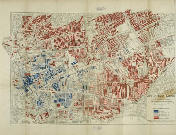
A Jewish population Map by George Arkell: 1899
© Museum of London
product details
Overall size of this product is
.
The image area of the print measures
.
description
A map by George Arkell showing by colour the proportion of the Jewish population to other residents of East London, street by street, in 1899. The map is part of the book The Jew in London: a study of racial character and present day conditions.
additional information
Artist/Photographer/Maker
George Arkell
Date
1899 AD - 1899 AD
Image Number
008625
A Jewish population Map by George Arkell: 1899
£25
00
£25.00
Art print / Small / None - £25.00 GBP
Art print / Small / Black - £85.00 GBP
Art print / Small / White - £85.00 GBP
Art print / Small / Gold - £85.00 GBP
Art print / Small / Natural - £85.00 GBP
Art print / Medium / None - £40.00 GBP
Art print / Medium / Black - £110.00 GBP
Art print / Medium / White - £110.00 GBP
Art print / Medium / Gold - £110.00 GBP
Art print / Medium / Natural - £110.00 GBP
Art print / Large / None - £60.00 GBP
Art print / Large / Black - £145.00 GBP
Art print / Large / White - £145.00 GBP
Art print / Large / Gold - £145.00 GBP
Art print / Large / Natural - £145.00 GBP
Art print / Extra large / None - £80.00 GBP
Art print / Extra large / Black - £170.00 GBP
Art print / Extra large / White - £170.00 GBP
Art print / Extra large / Gold - £170.00 GBP
Art print / Extra large / Natural - £170.00 GBP
Unstretched canvas / Small / None - £40.00 GBP
Unstretched canvas / Medium / None - £50.00 GBP
Unstretched canvas / Large / None - £60.00 GBP
Unstretched canvas / Extra large / None - £80.00 GBP
Stretched canvas / Small / None - £60.00 GBP
Stretched canvas / Medium / None - £75.00 GBP
Stretched canvas / Large / None - £90.00 GBP
Stretched canvas / Extra large / None - £120.00 GBP
Add to Cart
Share
Share on Facebook
Tweet
Tweet on Twitter
Pin it
Pin on Pinterest
choosing a selection results in a full page refresh